|
Wednesday, October 23, 2019
EPA September/October 2019 Fish/Shellfish Program News

Tuesday, October 8, 2019
Chronic Wasting Disease getting broader attention
 Chronic Wasting Disease (CWD) has been a problem in the Mid-Atlantic states for several years. It's now becoming a concern nationwide.
================================
from CNN:
"Zombie" deer roam 24 states in the US, sickened by a neurodegenerative disease that reduces them to stumbling, drooling creatures.
So far, Nevada has evaded the infection this hunting season. State wildlife officials plan to keep it that way.
The Nevada Department of Wildlife is urging hunters to visit their mobile sampling stations and check their carcasses for chronic wasting disease, a fatal illness that affects the brain and spinal cord of deer, elk and moose.
The department set up stations at truck stops near state lines to keep the infection out. The sampling takes about five minutes and doesn't affect the deer's meat or antlers, the department said.
It's the latest measure to protect the state's wildlife. In May, Gov. Steve Sisolak passed legislation banning hunters from bringing deer, elk or moose carcasses into the state to prevent disease transmission.
Chronic wasting disease
The symptoms of chronic wasting disease reduce infected animals to zombie-like creatures: Stumbling, drooling, drastic weight loss. They can become more aggressive and less afraid of humans, according to the Centers for Disease Control and Prevention.
It's thought to spread through direct contact with body fluids or by drinking contaminated water, the CDC said. The disease is always fatal.
As of August, the CDC reported infected deer, elk and moose in 227 counties across 24 states, primarily clustered in Wyoming, Colorado and Kansas.
There's a low risk of transmission to humans, but the CDC warned hunters that the species barrier may not fully protect them from contracting the animal disease.
Chronic wasting disease can incubate for more than a year before animals present symptoms, so the CDC recommends hunters test meat before consuming it and avoid eating the meat of infected venison. Wearing proper equipment while field dressing deer carcasses and minimizing time spent handling their brain and spinal tissue, where the disease originates, can also prevent infection.
Sunday, October 6, 2019
Monitoring and publishing streamflow and flooding using NOAA gauges

You can go to the NOAA Weather Service Rivers page, then zoom in to look for a specific gauge:
Not all gauges provide predictive data, which require models built on anticipated precipitation and past precipitation impact models, integrated with upstream gauge data if available. You'll typically see a full week, including 5 days of past streamflow and gauge height, and a prediction for the next two days.
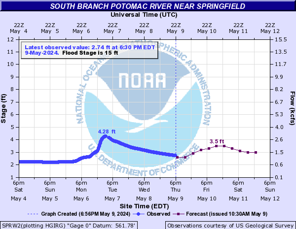
The images on these pages are dynamic, so if you visit this blog post later, you'll see the data in the image location above is changing. In order to capture an image of a flood event, you'll want to right-click the image and copy it or save it, as I've done below.

Monday, September 30, 2019
Great site for Mid Atlantic river levels
Monacacy Canoe Club provides many great resources to the public beyond its members. It's river gauge page and tools are great for all sorts of river users and explorers.
See the original page at http://www.monocacycanoe.org/gauges.html
Last update 1/09
See the original page at http://www.monocacycanoe.org/gauges.html
| ||||
Last update 1/09
Creek Critters App from Audubon Naturalist Society
An app from the Audubon Naturalist Society: Creek Critters walks users through finding and identifying the small organisms that live in freshwater streams, and generating stream health reports based on what they find. It’s available in the Apple App Store or in Google Play.
Saturday, September 28, 2019
How to Embed/Publish Slides to Your Blog
You may have to be logged into Canvas to view the video below.
Saturday, September 14, 2019
Leaf color changes
As your expertise grows, and others' awareness of your career grows, leaf color explanation will be an annual event (I'm betting it is already for some of you).
Like temperature and sunlight, soil moisture also plays a role in how the leaves will appear this fall. As day length gets shorter after the equinox (September 22), cells in each leaf create a layer that prevents new chlorophyll (it's called the abscission layer). Severe drought causes the abscission layer to form earlier and leaves often dry up or drop before they change color. Heavy rain and wind can cause the leaves to fall before they fully develop color.
The best color scenario is a growing season with plenty of moisture followed by a dry, cool and sunny autumn with warm days and cool but frost-free nights.
Subscribe to:
Posts (Atom)
EPA September/October 2019 Fish/Shellfish Program News
Check out EPA’s September/October 2019 Fish and Shellfish Program Newsletter ! Highlights include: Mercury ...

-
Monacacy Canoe Club provides many great resources to the public beyond its members. It's river gauge page and tools are great for all ...
-
Chronic Wasting Disease (CWD) has been a problem in the Mid-Atlantic states for several years. It's now becoming a concern nationwide....
-
Check out EPA’s September/October 2019 Fish and Shellfish Program Newsletter ! Highlights include: Mercury ...


